


powered by SignMyGuestbook.com

| Newest
Older Previous Next Random Contact Profile Host |
blizzard warnings - 13:52 , 03 October 2013 heelerless - 21:32 , 18 August 2013 Red Coat Inn in Fort McLeod - 11:38 , 23 June 2013 rushing into the waters - 09:53 , 21 June 2013 choosing a spot - 17:43 , 27 April 2013 |
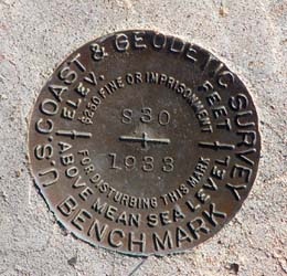
S30
Yet another benchmark.
This new hobby has become quite addictive. Every day my travels take me to a new place, I scan the database and the maps first, to see if there is one of these brass disks along the way to find. Or one of their more modern, more sterile, stainless steel rods.
Yesterday, it was this one.
A disk placed to mark a specific place for surveying purposes. Left to stand alone, through the seasons, through the years.
And it's an orphan. Abandoned by its parent agency, no longer kept in the database, no record even of the decision to abandon it. Just a tiny little 'X' on a map.
Yeah. 'X' marks the spot.
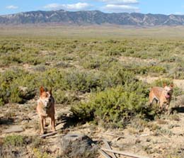
Which means the heelers and I had to find it the hard way. Navigate by the map. No technological coordinates to take us directly to the spot. So we left for the evening's classifications a little early. To make time for this little detour.
Didn't take long, though. I know how to read maps, and it was right where it was supposed to be.
Been there for seventy years.
Seventy years.
Abandoned and forgotten probably when they moved the highway, some thirty years ago.
But here it sits, still marking its place. A miniature monolith.
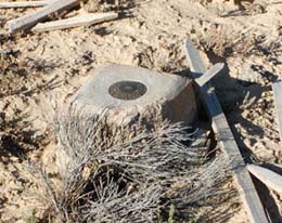
I touch the cool brass disk, and wonder about the men who set this here. For surely they were men, back in 1933. In a country still fighting off the Great Depression. Probably men who were grateful to have a job. Even if it did take them out into this barren wasteland. Muscled, tanned men who didn't mind digging a hole in this alkali hardpan. Lining the hole with boards, some of which were occasionally left behind in place, weathered grey and covered with lichen.
They would have mixed the cement by hand, having hauled it and the water out here into the desert. Probably in a pickup truck with a narrow box, still a new invention to some. Along the highway north from town. We traveled almost the same route, but at 64.7 mph (I set the cruise control by the GPS on the dash, not the speedometer). Got to our turnoff in less than a half-hour.
I don't know, in 1933? Could they have maintained 35 mph? Maybe only on the straight stretches. Either way, getting here would have been a major part of the day. Well, actually not. These benchmarks were laid out in series along the highway. I imagine the crew, or maybe just two men, camping in the desert as they wend their way up the highway, surveying as they go.
Perhaps they laid these markers before the highway? Now that's a thought. Driving cross-country from town to here, using the old wagon roads when you could, bushwhacking when you couldn't.
But either way, to get to S30 they only had to drive about two miles from R30. Who we found weeks ago on another short diversion. We've found Q, P, M, K and F, too. And W just the evening before. And also their cousins J and U, who were lucky enough to lie near the new highway, and have not been abandoned and forgotten.
This world was different when those lean, desert men laid that line of markers. Almost no antelope at all, yet this evening we classified seven does from the gate just a quarter-mile south of the benchmark. Wouldn't have been many fences or gates back in 1933, either. Maybe none. This was still sheep country, the sheep Capitol of the World. Bands of the white woollys everywhere, with their attending herders.
Sheep still grazed this spot for another 69 years. Until last October. Now the last of the last are gone.
The old highway is just about gone, too.
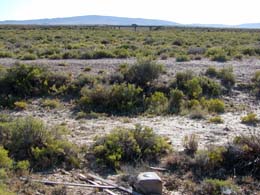
That's it in the foreground. A gentle ridgeline out in the greasewood, barely drivable now. The newer highway, already rebuilt once since it was moved, is just to the west. A newer cousin of this benchmark is set in the abutment of that bridge. The replacement that allowed S30 to be abandoned.
Been an interesting summer of traffic on that highway. There's major construction ten miles north of us, which holds back vehicles for 15-20 minutes. Or more.
Ten to 15 minutes of no traffic from the north. Then a huge pod of vehicles comes through, led first by the handful of speeders, who are never more than a mile ahead of the pack, then the rest. And finally a few stragglers, the overloaded semis and motor homes pulling trailers. I've counted. Drove 15 miles and met only four vehicles as I wended north. Then another 54 in five miles. Then nothing again.
The old road is rough, with chunks of old asphalt heaved up by frost and the plants. They strip the old asphalt off nowadays, melting it down to reuse on new road projects. But back in the 60s or early 70s, when this roadway was abandoned, oil was cheap and plentiful.
So they left it. And the plants have reclaimed most.
Wonder if it will ever be valuable enough for someone to come back and mine?
If so, little S30 will probably be here. Marking the spot.