


powered by SignMyGuestbook.com

| Newest
Older Previous Next Random Contact Profile Host |
blizzard warnings - 13:52 , 03 October 2013 heelerless - 21:32 , 18 August 2013 Red Coat Inn in Fort McLeod - 11:38 , 23 June 2013 rushing into the waters - 09:53 , 21 June 2013 choosing a spot - 17:43 , 27 April 2013 |
curving lines
Several hours of today were spent producing this:
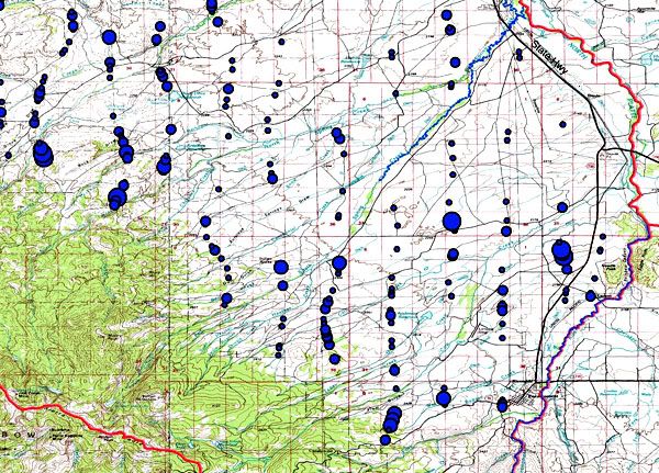
A map of where we saw pronghorn during our line transect survey last month.
The first thing you notice when looking at the map of the entire herd is that there were an awful lot of pronghorn living within five to six miles of the edge of the forest. Which was no surprise, having been sitting in the airplane. As the low country dries up, the pronghorn follow the green vegetation into the high country. Right to the edges of the trees.
Also no surprise was the dearth of antelope in the northern portion, where we lost so many two winters ago.
But the disappointing aspect of this map is the curves in so many of our supposedly straight flight lines. Sure, you can never fly a perfectly straight line. Not with our winds. The pilot did really well down in the flats.
The winds are strongest next to the mountains. I was handling the GPS, so I knew we were off line several times. But looking at these tracks, it's clear we were off line just about every time we got close to the mountains.
Which I can understand. Crabbing diagonally up and down mountains is an unnatural, and oftentimes unsafe thing to do in a small plane.
But what this all means is that the population estimate I made assuming straight flight lines is going to have to be redone, with estimated adjustments for the extra flight length in all those curves.
Not a big deal, true. Probably a less than five percent change in the estimate.
But still a pain.